Chablais english version

Chablais english version

CEN

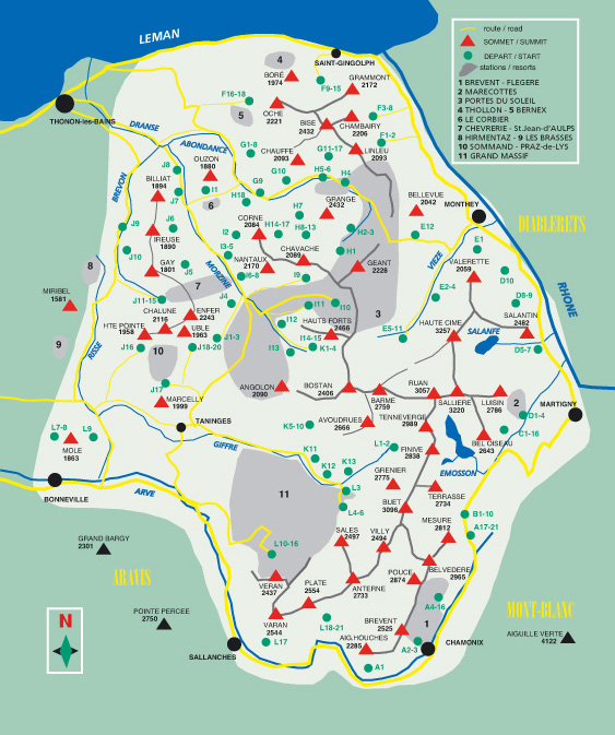
These mountains face the Mont-Blanc but some are not well known. This toponeige covers the French-Swiss mountainous area between the Arve valley, the Rhône river and lake Leman (lake Geneva).
First published in English : march 2009. Translated from the French by : Darin Reisman

Author: Jean-Baptiste Mang
Format: 110x170 mm. Stiff cover, bookmark
320 pages in color - 298 photos with route tracings
Language: English
EAN: 9782912063175

Are covered in this guidebook : the Aiguilles-Rouges and the Perrons ; the Hautes Alpes Calcaires (with the Dents-du-Midi) ; the Giffre basin and the Fiz range

191 primary routes (and 350 variations) provide an amazing variety of terrain from the gentler summits in the northwest, well suited for discovering the mountains in the winter, whether on skis or snowshoes, and the more jagged, often glaciated, Hautes-Alpes-Calcaires to the southeast

To better understand the rating system used in this toponeige:
Details of the toponeige rating

Toponeige Ski touring CHABLAIS
The Essential Reference for the Franco-Swiss Alps

Discover or rediscover the major routes of Northern Savoie and Valais with this edition of Toponeige Chablais.
Written by
Jean-Baptiste Mang, and translated by Darin Reisman, this work from Éditions Volopress stands out as the indispensable tool for planning your ascents and descents in ski touring.

Exceptional Geographic Coverage

This guide covers a cross-border territory of immense variety, facing the majestic Mont-Blanc massif. The work explores the entire area between the Arve, the Rhône, and Lake Geneva.


It details the following massifs, offering a unique panorama of the western Alpine arc:
The Aiguilles Rouges and the Perrons.
The Haute Alpes Calcaires (notably including the Dents-du-Midi massif).
The Giffre and Fiz massifs.
The Chablais massif, the northernmost of the northern French Prealps.
The proposed routes traverse terrains with varied geological characteristics, ranging from crystalline to limestone massifs, in mid-mountain as well as on glaciers.

Rich Content and Volopress Technical Expertise

True to Volopress's reputation, this work doesn't merely provide simple route descriptions, but offers detailed and comprehensive information to guarantee safe trip planning.
Key Figures of the Work:
Around 200 base routes accompanied by numerous variants.
A total of 320 color pages and 298 photos with route tracings for maximum visual comfort.

Pocket format 110x170 mm with rigid binding and bookmark, ideal for the field.


The Innovation of the Rating System: The guide uses the unique two-digit rating system of Toponeige, which goes well beyond simply evaluating steepness. This system allows for precise evaluation of factors affecting the actual difficulty of a route, notably incorporating:
The overall elevation gain and altitude.
The continuity and configuration of the slope (narrow couloirs or wide slopes).
The lighting, as shaded passages are considered psychologically more intimidating.
The snow quality (requiring edge balance for packed snow, or allowing flat skiing for deep snow).


This work, designated as Cold informations (stable route) by its publisher, serves as essential support for real-time condition information. It is designed to be the reliable paper reference that every ski tourer should possess to understand the complexity of the Chablais and Aiguilles Rouges massifs.